The Fairfield Local Housing Strategy (“the Strategy”) seeks to meet the aims of the Fairfield Local Strategic Planning Statement (2020), Fairfield City Plan (2016), the NSW Government’s Strategic Plans: A Metropolis of Three Cities - The Greater Sydney Region Plan (2018) and the Western City District Plan (2018), the “District Plan”.
The Strategy will guide future planning decisions that promote well-designed, accessible and safe places for the community, including active transport, and encourage walking and cycling within town centres.
The Strategy has been has been prepared in line with the requirements of the District Plan and effectively provides a 10-year review of the previous Fairfield Residential Development Strategy (2009). This approach ensures that the strategic and planning context are aligned with community goals and expectations, and updated with information from the 2016 Census, current housing supply and population forecasts and implementation and delivery plans.
Key Findings and Recommendations
The Local Housing Strategy (LHS) identifies a number of key centres and areas located within the eastern half of Fairfield City that are suitable for an increase in housing diversity and affordability to meet the changing needs of the community. These areas include Fairfield, Fairfield Heights, Fairfield East and Villawood.
The Strategy focuses on the future development in the short term (2016-2021) to medium term (2021-2026) within these centres and provide opportunities for increased future redevelopment outside these centres, including:
- Areas around existing centres and train stations, services and facilities in the medium term (2021-2026) including Cabramatta, Canley Vale, Carramar, Smithfield and Yennora.
- Areas around Bonnyrigg Town Centre are planned for increased residential density, including Land and Housing Corporation controlled land which is currently being redeveloped (2021-2026)
- Areas around the existing Liverpool to Parramatta Bus Transit way stations will be investigated for additional residential density in the medium to long term (2021-2036) including Wetherill Park, Prairiewood, Greenfield Park, Edensor Park, Bonnyrigg, St Johns Park, and Wakeley.
- Areas around future proposed public transport investigation areas in the longer term (to 2036) including Prairiewood.
- Areas in the rural lands in the short, medium and longer term depending upon unique local circumstances including utility servicing, housing and employment lands market demand and conditions, landowner expectations and aspirations and significant road, drainage and social infrastructure funding and provision.
Fairfield Local Housing Strategy 2022(PDF, 8MB)
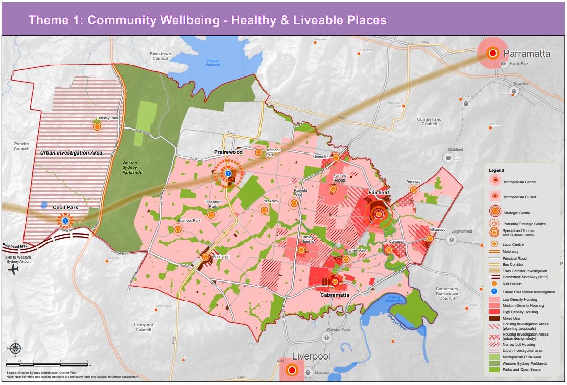
About the "Healthy and Liveable Places" Map
The map illustrates the different types of major town centres within our Local Government Area (LGA), as well as the surrounding LGAs. The map identifies how Fairfield Council could potentially be connected with the larger metropolitan centres Parramatta CBD and Liverpool CBD.
It is identified that Fairfield is our largest existing strategic town centre with a train station, which is surrounded by smaller local centres, Cabramatta, Canley Vale, Villawood, Canley heights, Bonnyrigg, Fairfield Heights and Smithfield. Prairiewood is displayed to be a potential strategic centre with an ongoing investigation to construct a future train station, this leads to further analysis for potential connection from Parramatta to the Western Sydney airport via Prairiewood town centre.
The map also identifies range of densities around the town centres, the open space areas, the Urban Investigation area in Horsley Park and Cecil Park and the Western Sydney Parklands.