Catchments are the area of land from which rainwater drains into a common point such as a reservoir, pond, lake, river or creek.
The water may drain or flow from the surface of the land (surface run-off) or from water that flows between soil and rock beneath the earth's surface (groundwater). In urban areas such as Fairfield, the majority of the rainwater is collected by gutters and pipes and then flows through stormwater drains into the stormwater system.
Creeks in the City flow into the Georges River and Hawkesbury-Nepean Catchments along a length of 80km in eight major creek lines. Creek corridors are comprised of the native vegetation that grows from the water's edge on to the land and are important for native animals.
Wetlands are an area of land where the soil is very wet and the land is permanently or seasonally covered by water. Wetland habitat is part land, part water. Wetlands support a range of vegetation particular to wetlands and provide food and shelter to many kinds of wildlife. They also help in improving water quality by acting like a stormwater "filter".
The impact of development in the past 50 years has resulted in severe degradation of the natural habitat and water quality in these creeks and wetlands that feed into the City's three catchments:
The Hawkesbury-Nepean Catchment to the west fed by the South Creek Sub-Catchment consisting of South Creek, Eastern Creek and Ropes Creek and the Georges River Catchment to the south and east fed by the sub-catchments of Prospect Creek and Cabramatta Creek.
Since 2011 the Georges River Combined Councils Committee (GRCCC) has embarked on the development of the Coastal Zone Management Plan (GRCZMP) for the Georges River.
Council's Creek Care Program encompasses creek cleaning, re-vegetation, weed control and bush regeneration of more than 60 different sites across the City, including along our riparian corridors and wetlands, parks and reserves. More than 100 tonnes of litter is removed every year from the suite of stormwater quality improvement devices located throughout the City. The program involves professional bush regenerators, community group volunteers, school students, and Council staff.
The long-term aims of the Creek Care Program are to create a beautiful creek environment that the community enjoys, healthy and well maintained creeks to improve the liveability of the City, to protect and promote local biodiversity and ecosystems through restoration work to create corridors of "green and blue" for wildlife connections, and to balance re-vegetation with flooding and water quality.
A program has been developed with three phases of restoration: primary (large, woody weeds), secondary (smaller herbaceous weeds) or maintenance. The most intensive and costly work is done on the primary sites to get the area established. Once sites are established they move to secondary and finally to maintenance areas that require minimal care/cost.
Stormwater is rainwater that flows off land.
When it rains, some stormwater is collected from your roof, driveways or paved and landscaped areas. It flows over land, or through the pipes and drains, to the existing public stormwater system and into our creeks.
Council's Stormwater Levy allows an additional $1.2 million a year to be dedicated to significant stormwater-related environmental projects. Funds spent each year are reported in Council’s annual report, separately from the rest of Council’s budget. The Local Government Act provides councils with the ability to implement a program of major improvements to stormwater management, funded by a Stormwater Levy.
Funds are allocated to urgent work to improve the quality and/or quantity of water in our local creeks and help stop buildings being flooded. All projects will be designed using best practice, incorporating designs that save, re-use and improve water management. This is called water sensitive urban design.
Stormwater Program is compiled from the investigations of Council staff, initiated from various sources such as drainage studies, requests/complaints received and other known drainage trouble spots throughout the city. Council’s database ranks projects on the basis of hazard. A summary of the criteria follows and is listed in descending order of priority.
- Situations where house floor levels are inundated or public safety is at risk
- Situations where out-buildings are inundated
- Situations where the property is inundated (yard flooding)
- Situations which cause a nuisance, such as long term maintenance problems
The State Government has also directed Council to develop and implement a catchment-based Stormwater Management Plan (SMP). Guidelines for the ranking in the SMP were developed by the State Government agency responsible for administering the development of the Stormwater Management Plans. This SMP is used to rank and prioritise stormwater management strategies along with Council’s existing database of stormwater drainage requirements.
Water quality is monitored at various sites along selected waterways creeks along the 80km of creek corridors in Fairfield City. The results of the Water Quality Monitoring Program identify priority projects and works. Details of the water quality sampling are reported in Council's State of the Environment Report.
Fairfield City Council is a member of the Georges Riverkeeper which, with other member Councils in the catchment, undertakes projects and monitoring to improve the quality of the Georges River and its tributaries.
Georges Riverkeeper advocates for the protection, conservation and enhancement of the health of the Georges River. Work focuses on five strategic priorities: catchment actions (such as litter removal and bush rehabilitation), river health monitoring and research, stormwater, and education and capacity building.
Georges Riverkeeper represents the eight local councils in the Georges River Catchment of NSW with a collective responsibility for the health of the Georges River. Members include Bayside Council, Campbelltown City Council, City of Canterbury Bankstown, Fairfield City Council, Georges River Council, Liverpool City Council, Sutherland Shire Council and Wollondilly Shire Council.
Read more about Georges Riverkeeper and the goal of best practice environmental management for a liveable urban river at https://georgesriver.org.au/.
Completed Flood Mitigation Projects
Creek Restoration Projects
Water Quality Improvement Projects
Fairfield City Council is upgrading Fairfield Golf Course Detention Basin to help improve flood mitigation and protect properties in the area.

Watch the video "Fairfield Golf Course Detention Basin"
Assyrian Translated: Watch the video "Fairfield Golf Course Detention Basin" in Assyrian
Vietnamese Translated: Watch the video "Fairfield Golf Course Detention Basin" in Vietnamese
Mandarin Translated: Watch the video "Fairfield Golf Course Detention Basin" in Mandarin
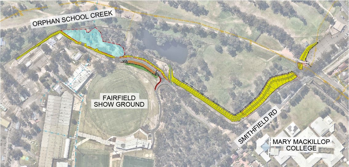
The Fairfield Golf Course Detention Basin is one of 19 flood detention basins owned by Fairfield City Council and is located within the Fairfield Golf Course and Fairfield Showground sites.
Due to the age of the basin, the works are necessary to ensure:
- A higher level of flood protection to the local community
- Its structural integrity in large flood events
- It has functional and operational longevity into the future.
The type of works that will be carried out on site as part of the Fairfield Golf Course Detention Basin upgrade are:
- A full reconstruction of the existing detention basin embankment and spillway along its 940m length
- Raising the minimum embankment level
- Reconstruction of a new access road, cycleway and footpath, plus construction of 27 new car parking spaces
- Landscaping and turfing of the embankment and adjacent areas.
| MAP LEGEND |
| |
|
EXTENT OF WORKS |
|
|
|
ADDITIONAL CAR PARKING SPACES |
|
|
|
INFORMAL PARKING |
|
|
|
DRAINAGE |
|
|
|
LANDSCAPING |
|
|
About the Location of the Detention Basin
The detention basin stretches from Orphan School Creek, past Fairfield City Show Ground and then alongside a stretch of Smithfield Road, opposite Mary MacKillop College.
Closures
The Fairfield Golf Course will remain open, however the driving range will be closed during the construction period.
Construction is scheduled for completion in May 2023.
- Project type Detention basin
- Completion Mid 2025
Watch the video "Powhatan Park Detention Basin"
Vietnamese Translated: Watch the video "Powhatan Park Detention Basin" in Vietnamese
Mandarin Translated: Watch the video "Powhatan Park Detention Basin" in Mandarin
The Powhatan Park Detention Basin is one of 19 flood detention basins owned by Fairfield City Council and is located on Mimosa Road, Greenfield.
Due to the age of the basin, the works are necessary to ensure:
- A higher level of flood protection to the local community
- Its structural integrity in large flood events
- It has functional and operational longevity into the future.
The type of works that will be carried out on site as part of the Powhatan Park Detention Basin upgrade are:
- Creation of a new spillway that is protected from erosion
- A partial reconstruction of the embankment and smoothing of the embankment crest
- Replacing the existing culvert under Mimosa Rd with a larger culvert (pipe that carries water away from the area)
- A new cycleway and footpath
- Creek bank restoration works in Wylde Park, directly downstream of the basin
Mimosa Road will have traffic control while the works are done. Powhatan Park fields will remain open, but ease of access may be impacted during the construction period.
Construction: February 2024 to December 2024


Construction is scheduled to finish mid-2025.

Watch the video "Upgrading Detention Basins"
With the help of generous Australian Government funding, Fairfield City Council is upgrading Stockdale Detention Basin to help improve flood mitigation and protect properties in the area.
The Stockdale Detention Basin is one of 19 flood detention basins owned by Fairfield City Council and is located within the suburb of Abbotsbury, at the headwaters of Orphan School Creek directly west of Cowpasture Road.
Due to the age of the basin, the works are necessary to ensure:
- A higher level of flood protection to the local community
- Its structural integrity in large flood events
- It has functional and operational longevity into the future.
The type of works that will be carried out on site as part of the Stockdale Detention Basin upgrade are:
- Raising the minimum embankment level
- Creation of a new spillway that is protected from erosion
- Reconstruction of pond separation bund
Use of Stockdale Park will be restricted during the construction period.
Construction is scheduled for completion in December 2025.
Council owns 12 dams and conducts safety standard reports on our dams yearly. View our Annual Dams Safety Standards Reports below.
- Annual Dams Safety Standards Report 2025 Basin C(PDF, 4MB)
- Annual Dams Safety Standards Report 2025 Basin W2(PDF, 4MB)
- Annual Dams Safety Standards Report 2025 Basin W3(PDF, 4MB)
- Annual Dams Safety Standards Report 2025 Bosnjak US(PDF, 4MB)
- Annual Dams Safety Standards Report 2025 Comin Pl(PDF, 4MB)
- Annual Dams Safety Standards Report 2025 Emerson(PDF, 4MB)
- Annual Dams Safety Standards Report 2025 Fairfield Golf Course(PDF, 4MB)
- Annual Dams Safety Standards Report 2025 King Park(PDF, 4MB)
- Annual Dams Safety Standards Report 2025 Mimosa Rd(PDF, 4MB)
- Annual Dams Safety Standards Report 2025 Stockdale(PDF, 4MB)
- Annual Dams Safety Standards Report 2025 Knight Park(PDF, 4MB)
- Annual Dams Safety Standards Report 2025 Hassall St(PDF, 4MB)